Category Archives: Washington

Yellow Aster Butte
My preparation for the 2021 Devils Dome Trek included a day hike up Yellow Aster Butte on 8/29/21 which provided good distance, elevation and beauty. I chose this hike because I never really got to experience the upper portion of the trail back in 2016 due to weather that was not cooperating.


My 2016 hike was later in Autumn and I had gotten a late start that day so I decided not to climb to the upper view with the weather uncertainty. Brook was with me in 2016 and the Autumn colors on that hike were indicative of the trail’s name.


I wanted to get the full Yellow Aster experience and I also needed the workout of 7+ miles and 2500′ vertical climb. A beautiful Day made for a great hike. It was a Sunday so I knew that I would be competing with other hikers for parking and trail space. Many hikers were coming down after spending the night. The trail starts out with many switchbacks giving you awesome views of Mt Baker.


You can count on water from a mini glacier just before the final steep climbs.

The final climb, which is not really up to the Butte but to the peak just to the southeast of it is steep so your heart will be pumping. However, the reward of the 360 degree views are totally worth it.


I was fortunate that the wind was not an issue which made for an enjoyable lunch break at the top. These are the times when you really appreciate access to the mountains here in the North Cascades, I was totally ready for the Devils Dome Trek. The hike back down was predictable with anticipatory thoughts of Beer and Pizza from the North Fork Brewery in Deming on the road back to Bellingham.


Devils Dome Loop – Clockwise
I love multi-day backpacking loop treks and the Devils Dome Loop in the North Cascades turned out to be a jewel. I was a bit surprised to come across it only finding a few trip reports. The distance and vertical are very similar to the Timberline Trail but the the effort was far greater.


Most people approach the loop counterclockwise since the initial 4000′ climb is more moderate thanks to switchbacks. But I opted for the clockwise route to coordinate better with the North Cascades National Park permitting for the first night. My common backpacking partner, Bryce, was going to be challenged with getting there at a reasonable time on September 1st, so I opted for a campsite halfway along the East Bank Trail at Roland Creek. We did not hit the trail until 7 PM, so night hiking was required. One issue worth mentioning, especially when searching for your campsite in the dark, was that the campsite shows up on the typical topo maps as being south of the creek when, in fact, it is north of the creek. But it did turn out to be a good site for setting up in the dark.


We hiked about 6 miles to Devils Creek Landing on Ross Lake, where we had lunch and a rest before the big climb. The climb to Devils Dome, or at a minimum Bear Skull Cabin, was going to be the make or break for my body, which is why I had been putting in extra vertical training in recent weeks. Water is an issue, and the most dependable source supposedly would be found at Bear Skull Cabin, 4000′ up. We were told that there was a stream at about 3000′, so we only carried 2 quarts, which was adequate for our perfect cool weather climb.


However, 4000′ mostly straight up does kick your butt. Bryce and I slogged along and finally reached the cabin after a 6-hour climb. I believe I got all that I could from my body on this climb, so my training turned out to be totally justified. Now I understood why this loop is not more heavily traveled. The climb from the other direction is probably easier due to water and switchbacks, but 4000′ is a tough climb, especially for an old backpacker. We did have a nice campsite just off trail toward the cabin. The night was totally clear, with magnificent stars that I was too tired to enjoy.


The next day required another 1000′ climb up to Devils Dome which lived up to the hype for a fabulous 360 view of the North Cascades looking into Canada. The day was clear with some cloud cover moving in later, temperature at about 60 and no wind. This was as good as it could get.
Up till now we were also sharing the trail with the Pacific Northwest Trail, PNT, but that would end as we approached Devils Pass. Supposedly there is water on this 6 mile stretch but I don’t remember seeing any.


We were carrying enough water to make it to Granite Creek, which turned out to be our choice for a campsite after about an eight mile day. The trail over to Granite Creek was one of the most pleasant and beautiful stretches of hiking that I have ever experienced.


However, more campsite information would have been helpful. On the north side, there is a campsite about a quarter mile up a steep trail from the stream. We opted to go to the creek, assuming there would be campsites. Well, we only found one campsite barely large enough for two tents, which was just south of the creek as you enter the trees. This worked out fine since there were hardly any other backpackers on this loop. And we did keep commenting on this lack of traffic, especially on the long Labor Day Weekend. I guess the high vertical entry price to this loop keeps the crowds away.


Leaving Granite Creek hits you with a couple of tough 700+ ft climbs, the second being switchbacks up a fairly steep scree field.


These climbs were tough with legs that were worn out from the previous climb but were encouraged by fantastic views of Crater and Jack Mountain over beautiful valleys. The last climb was a bit precarious as you had to climb up a scree field with a few long switchbacks but also with a few really steep slippery sections. I think that I would rather be climbing here rather then descending.


We were again putting in about an 8 mile day planning to camp just before the final descent down to the Devils Park Trail which would take us back to our East Bank Trailhead parking lot.


We were again surprised that campsites were not more plentiful except for 2 to 3 miles up from the start of the descent. There was only one good campsite before the descent and it was fairly large but taken. Luckily the people there had scouted the area and found a hidden campsite a short distance behind theirs which turned out to be perfect for Bryce and I. The last day required us to descend down to Canyon Creek which was rather easy considering the number of switchbacks. This video captures my gratitude.
The long descent to the canyon floor.


At the crossing area over to the the Trailhead there is no longer a bridge, however, the stream ford is not to difficult. Plus there is a landslide just west of this crossing which forces you to ford the stream just to get around the landslide and back to the Devils Park Trail. Now you get to finish up the trek with a gentle 3+ mile hike along the stream.


Bryce and I agreed that the Devils Dome Loop is a special one, however, we would classify it as more technical or difficult. Our bodies were totally spent but it “Hurt So Good”. My advice, I originally planned to camp at Devils Creek on the 1st or second night to set up better for the long climb up to Devils Dome. One bummer for the trek was finding that thieves had stolen Bryce’s Catalytic Converter off his Toyota 4Runner.


Stevens Pass to Stehekin
 I had completed my warm up treks and was ready for a new Adventure. I had not done Stevens Pass north on the PCT, but I had done Suiattle River access to Rainy Pass, so that first portion of the PCT Section K was at the top of my list. It is a long stretch of 107 miles and lots of vertical, oh well, no problem other then carrying enough food.
  I planned for 10ish days knowing that I don’t have an appetite on the trail which would allow me to stretch my provisions if needed. Weather was going to be excellent except that it was warmer than usual. My travel logistics were easy starting with spending a night in Chelan Lake State Park, leaving my car at Lady of the Lake long term parking, catching the free metro link bus to Wenatchee and then taking a Trailways bus to Stevens Pass. I was on the PCT going north by 3:00 pm on July 27th. However, this trek seemed more daunting then usual. I had not been solo for a number of treks and the distance was 30% longer then I had even taken on. My mind was telling me how nice it would be to be sitting on my deck drinking a beer and my legs were already telling me they were tired. This is always the challenge, to force yourself to just do it and after a few days you know it was the right call, because getting out there is what it is all about. Unfortunately key comfort factors were not in my favor. Temperatures were flirting with 80 degrees and the bugs must have just hatched. The positive was that water was not an issue and the wild flowers were good. So I was “On the Trail Again”.

First Night’s Campsite

Lake Valhalla
My goal for the first night was Lake Valhalla which push me a bit. I chose a campsite in a meadow where I discovered just how aggressive the mosquitoes and flies were going to be. But I was generally so tired at my campsites that I was content with escaping the bugs and getting to sleep. My goal for the second day would be Grizzly Peak thinking that the bugs would be better up high. This was only about 9 miles and not that much vertical, but it was hot.


My campsite plans for Grizzly Pass were fine except that the bugs were worse up high, so I did not hang out side much to enjoy the view.
The third day took me past Pear Lake which appears to be very popular due to alternative trail access options. I decided not to climb to Lake Sally Ann and opted for a night at Pass Creek which turned out to be much better with respect to the bugs. The goal for the next day was Indian Pass.


I was told about a great campsite by taking a trail from the Indian Pass sign. Yep, it was primo complete with a toilet, campsites in a thicket of trees next to a large meadow. However, the bugs were the worst yet. That night was kinda weird because a herd of deer bedded down around my tent. The next day would be about Red Pass.


Campsite plans were to deal with the ford of White Chuck Creek and camp on the north side. This ford complete with a buckled bridge and getting your feet wet was rather refreshing with a nice campsite reward.
The next climb would be Fire Creek Pass but I was wearing down so I opted to camp somewhere around Fire Creek. This section was a low milage day for enjoyment, bugs were not bad and the views were awesome. My body was wearing down since I had burned all of my easy fat and I needed to start eating more.


Fire Creek Pass was another beautiful event with plenty of snow, probably the most difficult of the trek.


On the way down I got the word that Milk Creek was an overgrown mess and that I could get water on either side. So my plan was to cross Milk Creek get water and find a campsite somewhere up the other side. The problem though was that for a mile before Milk Creek the overgrowth was so bad it was essentially bushwacking and the same was true on the north side. It was getting late in the afternoon, it was hot and the bugs were horrible as I tried to fight my way up from Milk Creek.


I was really getting tired so I was beginning to consider camping on the trail if I had to. It did not look good for finding flat ground for a campsite, but then I see a sign that says “Toilet”. Thank you God, I really needed to stop, there was no toilet but there were a couple of campsites. Now I needed to recover for the climb over Grassy Point the next day.


This was a tough day, the body was dead but I think the gorgeous scenery carried me over Grassy Point knowing that it was then down to the Suiattle River with one more huge climb to go.  It was around this part of the trek where I decided that I needed to finally put in a Hot Tub at our house. Thoughts of how I would install this tub provided a needed distraction for many days. I opted to camp next to Vista Creek and take on the Suiattle River crossing and climb the next day. Turned out to be a great campsite where I had my first fire.
At the major bridge over the Suiattle River I took a long break to recharge my body and iPhone. I had about a 3500′ climb ahead of me so I just wanted to knock off as many miles as I could before camping.
I ended up at the Skyline camping area where there was a large Forest Service work crew just setting up.

Suiattle Pass
Now the climb up and at least a little over Suiattle Pass. I was dragging but I made it to a nice campsite just over the pass complete with the most bugs of the trip.
It was Thursday August 6th and I had about 18 miles to go but it was mostly all downhill. I wanted to get close enough to High Bridge that I could catch the shuttle at noon on Friday. The hike down did have some more small climbs and the weather was changing to a light rain, plus I was running into more overgrown trail so I felt that camping at Swamp Creek 8 miles out from High Bridge would be fine. Plus I was soaked from the waist down due to the moisture off the overgrowth.


Almost to High Bridge
It was a nice last night on the trail even though it did rain off and on all night. But it was dry when I packed up for my final 8 “easy” miles to go. Not so easy as in some more up and downs with plenty of overgrown trail. The sight of High Bridge was so welcomed.
High Bridge
The normal Stehekin shuttle is not running this year, however, the Stehekin Valley Ranch is providing the service which gives you a hour layover at lunchtime to at the Ranch, just right for fueling up on a burger. I then stopped at the Stehekin Pastry Company where I had the best piece of Cherry Pie I think I have ever had.

I then set up camp in the National Park Lakeview Campground and proceeded to down a few brews from the store before it closed at 4:00 pm. The next morning I went back to the Bakery for breakfast and had a nice 2 mile walk back to get ready for my ferry ride back to Chelan.


Goodbye Stehekin
Overall a great trip, but it was also the most difficult trek I have ever completed and now 4 days later I am just starting to feel recovered.

Great PNW Multi-day Backpacking Loops

I have been putting together an annual multi-day backpacking loop trek for my friends for the last 8 years. The goal was to find a 4 or 5 day trek of moderate difficulty based on a loop to simplify travel logistics.
The first trek was through the Sisters Wilderness in 2011 and during each trek we would ask other backpackers what they thought was another great loop option. This advice truly led us to discover and confirm the finest multi-day backpacking loop treks in the Pacific Northwest. Since I have answered this question for other backpackers through the years I decided to create post to highlight these loop treks. The order presented is based on the order in which I discovered these treks. Please feel free to share your similar favorite loops.
Three Sisters Wilderness

There is a 50 mile loop that encircles the 3 Sister Peaks, however, I selected an approximate 35 mile route that starts from the Lava Lake Trailhead and cuts through between the Middle and South Sister peaks. This was my first multi-day trek for which I named the post “No Pain No Gain“, reflective of efforts and rewards of backpacking. The route adhered to the 4 to 5 day goal while adding the challenge of being up close to the Sisters. I would recommend the clockwise route with attention paid to water availability on the first day. Camp Lake through to the Chambers Lakes typically presents the challenge of climbing through snow but you need to experience the view from up there. You have to time this trek to allow for the snow crossing while also taking in a maximum floral display without too many bugs. The east section which is the PCT takes you through lush forests into lava fields. Passing through the restricted Obsidian area is not a problem, however, you want to time your climb over Opie Dilldock pass during the cool part of the day. The Mattieu Lakes near the start and finish offer good rest options. You could also consider doing this loop from the Pole Creek Trailhead.
Eagle Cap Wilderness

The Eagle Cap Wilderness was enticing, however, piecing together a loop was not as obvious. I settled on using the Two Pan Trailhead to enter via the Minam Lake Trail and returning via the East Fork Lostine Trail while taking in all of the options provided by the Lakes Basin area. This loop requires crossing the 8548′ Carper pass to settle around Mirror or Moccasin Lakes. Here you have the option of expanding the loop up and over Glacier pass through Horseshoe Lake to Douglas Lake. Or you could just base from the basin area and do a few day hikes to fill your trek. Either way you must experience Glacier Lake. The lakes here are deep and can provide some good fishing. You come out completing the loop via the East Fork Lostine Trail with a shrinking awesome view of Eagle Cap.
Goat Rocks Wilderness

Goat Rocks should end up on everyones list, however, with that popularity come the weekend crowds. The loop option is fairly defined with a starting point at the Berry Patch or Snowgrass Flats Trailheads. It could be treated as a 2 day loop, which is why you include spur hikes north & south on the PCT. Whether you go up Snowgrass or Goat Ridge Trails you will be doing the bulk of the climb and you typically will deal with the worst of the mosquitos and black flies. I like the Snowgrass Trail to the Bypass Trail over to the PCT. Once on the PCT portion of Goat Rocks you have access to Cispus Pass south or Old Snowy north which is worthy of a few nights. Then head over to the Lilly Basin Trail which takes you to the Goat Lake area. The lake is generally iced over, however, the campsite options around there provide an awesome view of the valley and Mt Adams. You may want to hike up to Hawkeye Point and you should be treated to herds of mountain goats above Goat Lake. Your hike out via the Goat Ridge Trail is essentially downhill.
Spider Gap Buck Creek Loop

The Glacier Peak Wilderness provides a classic 36 mile backpacking loop that takes you up a glacier to Spider Gap past the Lyman Lakes then over Cloudy and Suiattle Pass by Fortress Mountain and over to Buck Creek Pass and Liberty Cap. This trek is probably the most true loop and it may be the most challenging especially getting up to Spider Gap. You start at the Phelps Creek Trailhead and head up the Phelps Creek Trail as far as you can in preparation for the climb up the Spider Gap Glacier. Camping near the Lyman Lakes sets you up for the next climb to Cloudy Pass and then around to Suiattle Pass where you get your first glimpse of Glacier Peak. If time and energy allow you should consider including a visit to Image Lake along Miners Ridge. As you work your way around to Buck Creek Pass, Glacier Peak is positioned prominently to the west. Find a campsite with a view of Glacier and take a hike over to Liberty Cap. The final hike out is relatively easy from there.
Timberline Trail Around Mt Hood

This is a great loop trail around Mt. Hood with views of many other mountains. I have decided to do this loop every year because it is so perfect, and it provides me with a gauge for my overall health. The TT is approximately 40 miles with a number of potentially challenging stream crossings. The elevation low point is near Ramona Falls at about 3300′, with a high point on the east side at 7350′. There are many choices for a starting point, with the most common being at Timberline Lodge. Clockwise is the more common route from the lodge on the PCT, which takes you by the Zig Zag Canyon where you should consider detouring up to Paradise Park for an evening. Crossing the Sandy River may be the most challenging before you take in Ramona Falls. The PCT offers you a couple of options; I like the one up toward Yocum Ridge over to Bald Mountain before you head up the Timberline Trail toward McNeil Point. On the north side, you cross through some old burns, but the beauty is everywhere. Once past the Cloud Cap TH, you climb to above tree-line, typically crossing many snowfields. Copper Spur is a side trip option, and then you work your way down to Gnarl Ridge. All of this area is arid and treeless. Cross Newton Creek, pass some waterfalls, and head through Mt. Hood Meadows Ski Area. The final push is to cross the White River and then climb back up to Timberline Lodge. This final climb can be challenging due to the sandy trail and exposure.
My Annual Timberline Trail Trip Reports: 2017 2018 2019 2020 2021
I hope these backpacking loops help you find that perfect trek.
A recent loop that I have just completed does deserve mention; however, it is more difficult than my top 5. It is the Devils Dome Loop in the North Cascades of Washington.
I will also throw in another option, which is partially a loop. The Wild Rogue Loop diverges from the primary Rogue River Trail up to Hanging Rock.
I am moving to Grand Junction, CO, where I have targeted the Four Pass Loop in the Maroon Bells – Snowmass Wilderness to potentially replace my Timberline Trail Loop Annual Trek.

Suiattle River TH to Rainy Pass
Another one of those trips that I was denied in the past due to unforeseen events, in this case the Blakenship fire in 2015 that closed the PCT.

Suiattle River Trail
So I return to take it on starting at the Suiattle River Trailhead with Rainy Pass as the destination about 58 miles with a stop in Stehekin where a couple of buddies will join me. This trip was made possible thanks to a good friend who gave me a ride from Rainy Pass where I left my car to the Suiattle River TH. I had been on the Suiattle River Trail a couple of times with a great trip to Image Lake, so the first part of this trip was all prep for the climb over Suiattle Pass and on to Rainy Pass.
@AussieBrook and I got to the trailhead late Saturday June 30th but was still able to make it to Canyon Creek for the first night. It rained most of the day, but I was sparred from the rain for most of the hike.

Suiattle River Trail Slide
I was impressed with the work done to allow passage through a recent tree slide that blocked the trail. Overall the Suiattle River Trail is one of the finest in Washington.
The goal for Sunday was to get close to Suiattle Pass to prepare for the crossing the following day.

PCT Closure Sign from 2015
I ended up camping at Miners Creek PCT mile 2549. It was a damp day but again I was sparred from getting wet. Once I got on the PCT I started to encounter the first of the SOBO hikers. At my eventual campsite I met a young man who had been a HS Math Teacher but was now going to hike to Mexico. Unfortunately he had just come off a tough night where he had to make camp on a tuft of snow on Suiattle Pass due to a headache and darkness. I will give that young man a 50% chance of completing the PCT. From these hikers I did learn that there was a lot of snow on Suiattle Pass but at least I should be able to follow their footsteps. I was thinking a mile of so of snow. It was a bummer to wakeup to rain knowing that I would be hiking through snow. After I began my decent north from the pass into the Agnes River drainage I met other hikers who alerted me to the additional 4 miles of snow ahead.

Campsite Morning Sun
Overall it was about 5 miles of snow with occasional trail breaks. The snow was soft and footing was treacherous, I went down many times. But what a joyous day of rain, wind and snow. And to finish off the day I got to ford a cold stream. I ended up camping at a great established campsite at PCT mile 2557. Checkout this video of Brook scratching her butt. We were fairly soaked but the skies did clear and we woke to relatively dry sunny conditions.
I was so glad that I had started a day early then I originally planned since now I had the option to go to Stehekin on the 4th in preparation to meet my buddies on the 5th.


Plus this stretch along the South Fork of the Agnes was all down hill so we had an easy day except for a treacherous ford at PCT mile 2559.  Normally I might put on my crocs for a river ford but this river was roaring and my boots were already wet so I just sloughed my way through. Unfortunately, this river was flowing a bit too strong for my 35 lb dog, Brook. She got fairly nervous as I crossed first to leave my pack in order to come back to lead her. Nope, the current was too strong so I ended up carrying her across. From here on the sun was shining and we started to dry out. Ended up at a nice campsite PCT mile 2564.
Brook was in heaven chasing the many squirrels up trees that were far enough apart to prevent their easy escape.


She tormented the squirrels all waking hours that evening and the following morning.


July 4th we hiked to High Bridge enjoying huckleberries and then catching a ride with a park worker and hit the Stehekin Bakery for lunch.  The weather was superb so we thoroughly enjoyed our 24 hrs of rest. I wanted to go to the Ranch for dinner, however, they couldn’t really accommodate Brook. We ended up camping in the Lakeview campground with a Mountain House meal of Beef Stew before hanging out on the deck drinking beer with the many SOBO backpackers.

Lake Chelan
Also a big thank you to the store manager who was extremely accommodating for all and sold bottle of beer for $2.50.
July 5th my friends; Bob and Pete, arrived on the Lady Express boat at 11:00 am and I made them deal with the National Park campsite permitting for our remaining nights on the PCT portion of the trail inside the NP boundary up to Rainy Pass. We hit the trail in the heat of the afternoon which turned out to be the hottest day of the trip.


We only went about 5 miles to Bridge Creek Camp but with it being uphill it was a good workout.
The following day was again a climb but a beautiful lunch stop at the confluence of Bridge and Maple Creek offered a trip highlight.
We camped that night at Six Mile PCT mile 2583. We had some short rain periods to deal with along with more hungry mosquitoes but we woke up ready to finish the trip on Saturday 7th.


The final stretch offered many scenic views along with a number of interesting stream crossings. Since I had to take my buddies to their car in Chelan, I took the opportunity to stop at the Washington Pass Overlook to take in the American Alps.


Image Lake via Suiattle River Trail

I finally made it to Image Lake and boy was it worth it. On my Spider Gap Loop trip in 2015 we tried to get to Image Lake but had to turn back. After climbing the last 1400 ft from Miner’s Ridge on this trip I would say we made the right decision to backoff back in 2015. But I needed to get to Image Lake partly for fulfillment and partly to push the body into backpacking shape since this was my last weekend in the North Cascades before retirement the following friday. The trip is 32 miles with 4800 vertical with most of the vertical, 3300 ft, from the river trail. I planned on 3 days but I was not sure how it would play out.
The hike into the Canyon Creek campground was a possible first night destination, however, all campsites were taken thanks to a fairly large PCTA work crew. So I hit the PCT going North and saw that there would be a few campsites before the Image Lake Trail.
Shortly after Canyon Creek Brook and I were attacked by “Max” a combination Shepherd and Wolf. All I heard was “No Max” and around the bend comes Max in full charge. Brook got between my legs and held her ground but Max was only about attack. A serious fight broke out at my feet and I believe Brook realized she was not going to win. I heard a dog cry and then Brook took off running for her life with Max in pursuit. I think Brook chomped on some part of Max’s body which freed her for the get-away. Well Max’s owner chased after Max and I followed calling for Brook. Running with a full pack at my age is not what I should have been doing, but my dog was in trouble. After about a quarter mile Max was contained and I headed up the trail looking for Brook. I found her to be safe and injury free. Wow, I did not really say anything to Max’s owner because he knew how bad this was. He said that it was good that Max was tired. I was thinking it was good Brook is so fast. Overall, this was probably a good learning experience for Brook, to know that anything can happen and it is best to stay close to the Human you want to protect. Brook’s trail etiquette is almost perfect, but people don’t always understand how Aussies want to check them out.
Back to the trail with the temperatures rising to about 80 which was taking a toll on my body.  I would have loved to have been able to climb to Image Lake for the overnight view, but I was beat. Luckily there was a sweet campsite just before the trail to Image Lake. I decided to camp there and go to Image Lake the next day with my new lightweight day pack that I just bought at REI. This was the first time in a while that I have camped in a forest setting with lodgepole type trees with not a lot of distracting sound such as you would get from a rushing stream.
  The evening turned out to be wonderful listening to the wildlife and watching Brook try to stalk all of the local chipmunks. The sun setting between the trees was a whole different kind of beautiful sunset. I even took a selfie.


But I was tired and thanks to splurging by bringing my Therm-a-rest air mattress, I slept like a log. I did not use my fly which did offer some star gazing. Brook started out in the tent but she knew she needed to be outside to properly protect us. I did not try to influence her otherwise even though it was pitch black out.
Sunday morning and it is time to climb to Image Lake.

First Glimpse of Glacier Peak
I knocked off about 2000 ft to Miner’s Ridge as the temperature was again pushing 80.

Second Glimpse of Glacier Peak
The last 1300 ft nearly did me in, but I saved enough energy to properly explore not only Image Lake but the Miner’s Ridge Lookout Tower at 6210 ft. I was the only human up there and it was an amazingly beautiful day. This is why we backpack. The view of Glacier Peak is the highlight, the pan at the top gives you the full perspective.

The Suiattle River Drainage was also breathtaking
There was only snow at the top and Brook was loving it. Here Brook wants to go after a marmot on the other side of the lake.
The rest of the photos will speak for themselves.
Descending back to my campsite nearly did me in, thank goodness it was downhill. But on this second night I was really beat, no appetite either, but a serious thirst that I needed to quench. I put the fly on earlier and decided to leave it which allowed me to just sleep on top of my bag all night. Brook woke me at 5:00 am and I felt good so we hit the trail by 6:30 am. The hike back was uneventful but I continued to realize that my body was benefitting from this extreme exercise. I am writing this post because I am too tired to do anything else. I am going to sleep good tonight. I think I am ready for retirement.

Whatcom Lake Park to Stewart Mountain
Lake Whatcom Park near Bellingham, WA, must be somewhat of a secret since I just discovered it after 11 months of seeking out every good dog friendly hiking trail in the Bellingham area. All good though, the park is primarily known for its really nice and easy Hertz Trail along the lake. What I needed and the basis for this trip report is the trail that leads to Mt Stewart essentially parallel to the Wickersham Truck Road that begins at the end of P2 parking area. The road would continue but it is gated and the trail leads off from the NW corner of the parking area. You can also just hike the road but that is in high demand by the mountain bikers.


The trail winds through various densities of forest occasionally crossing the road. At the first road crossing you need to follow the road up about 100 ft to an opening on the left where you will pick up the trail again. The second road crossing is more obvious that the trail continues on the other side. That is not the case for the second half of the trip.

@Aussiebrook was very pleased with this trail
After a couple of road crossings you hit an extended stretch of trail that takes you to a smaller road spur. This section of trail is really nice offering significant flower cover. Turn right for the scenic overlook and left to find the trail again after a few 100 feet.
The overlook is essentially at the end of the offshoot spur road. You have a excellent view of both ends of Lake Whatcom as well as Bellingham and the North Puget Sound. This site appears that it has been used for some overnights.

Panoramic View of Lake Whatcom
I was going to give up assuming that this was the end of the trail, however, I did find the next section that reconnected with the road. At that point you need to climb on the road up to the next turn where you can pick up the trail again.
 This last section of trail offers occasional views of the lake but again you come out on the road.
  From here on I did not find any further trail options, the land contour did not lend itself to more trail connects, however the road was more like a trail. You then merge with the power lines which is a bit concerning because of the loud static crackling from the high voltage electricity transmission taking place. Oh well, I guess we got a charge out of it. Here you have a combination of some clear cut and major power line right of way up and over Mt Stewart.
The view is more impressive for distance, however, I rate the lower lake overlook as the prize view. The real value of this trail for me was the great exercise with approximately 2500 ft vertical. Also very little traffic on the trail since access to the lower lake trail is what dominates the available parking. This is exactly the training I need to prepare for my next career as a full time backpacker. Plus @AussieBrook loved it.

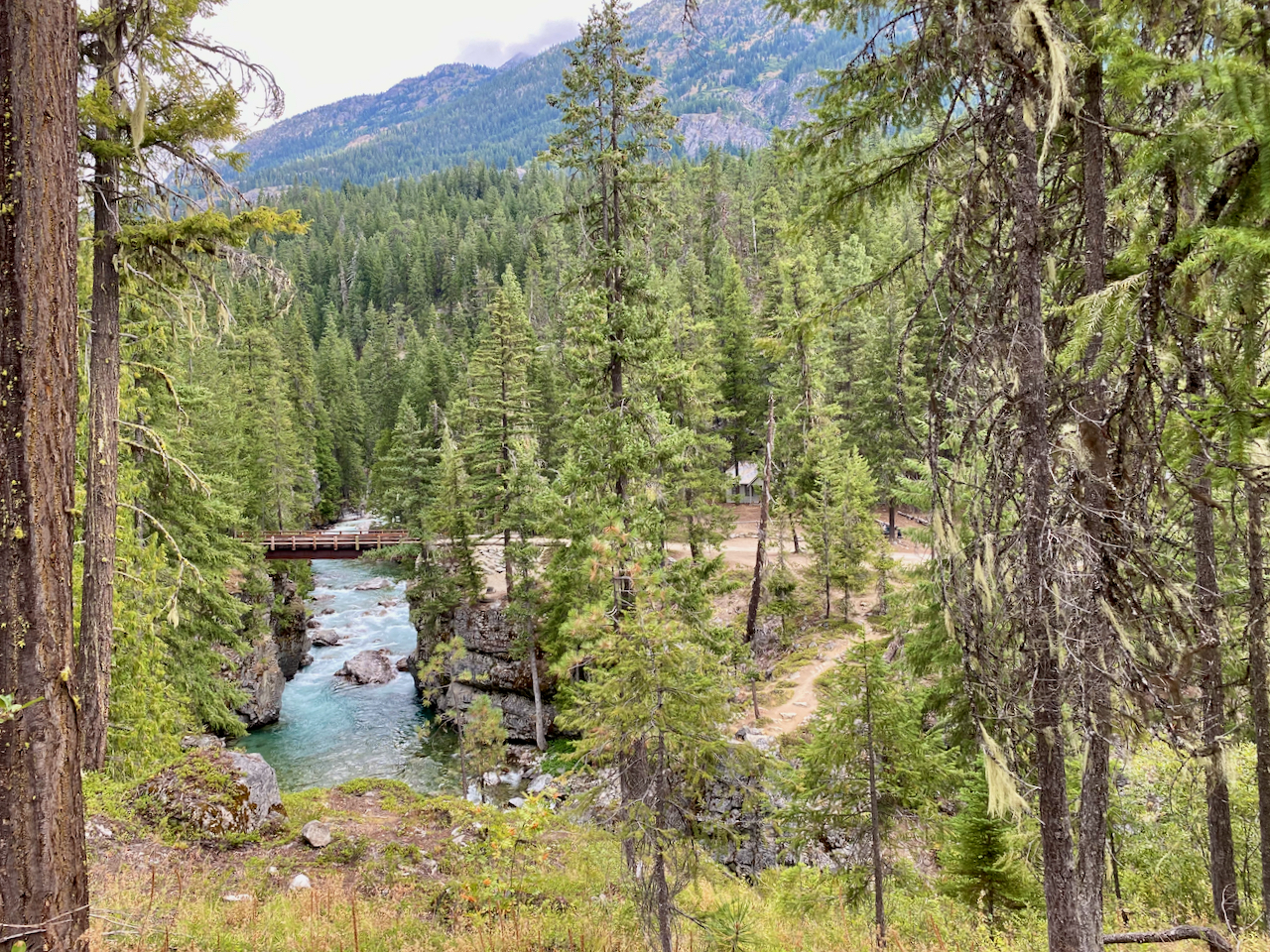
Suiattle River Trail
April 15-16, 2017, camped at Canyon Creek.
Finally a fairly nice weekend in 2017 for a backpacking trip with my Australian Shepard, Brook. She is about 17 months old with some backpacking experience, however, this would be her first with the responsibility to carry her own pack. All of this is in preparation for more extended trips as soon as I retire again at the end of June. I decided to take on the Suiattle River Trail because of the relatively low elevation which I assumed would bode well for snow level. Turns out there was no snow all the way to PCT mile mark 2540. The trail was actually fairy dry and the stream crossings were all easy.
The 23 mile drive in on FR 26 turned out to be uneventful as well. There are enough potholes on the second half gravel portion to force you to keep your speed down, but overall the road was in good shape. Only a couple of cars at the trailhead and I only saw 10 people all weekend. River trails tend to be fairly level with occasional views of the river but rarely any scenic vistas. That would hold true for this Trail, however, the lush green vegetation with many beautiful stream crossings offers its own unique charm.


The real goal for this trip was to test Brook’s interest and ability to be my backpacking buddy. I put a full 32 oz Nalgene in each side of her Ruffwear Palisades Pack. She was not thrilled by this requirement to carry her own pack, but she was committed to pleasing me.  She figured out what her cadence would be and soon she was in total work mode never straying more than a few feet from my heels.
  Actually, I am very proud of how she handled this. You don’t train an Aussie as much as you provide opportunities for them to learn. She totally understands the purpose of the backpack now and I believe is honored to have the responsibility.
The hike into Canyon Creek was relatively easy, which I am extremely grateful for considering I am still just a (old) weekend warrior right now. Considering 7 miles in and then an extra 3 miles up the PCT and 7 miles out on Sunday, my slightly sore muscles are not bad at all. The stream crossings we both beautiful and relatively easy.
The campsite was primo with an excellent fire pit, unfortunately, I did not plan for a fire and failed in trying to start one with only a bit of toilet paper and a few matches. Brook managed the campsite with great dedication and thankfully did not find anything with sweet dog aroma to roll in. Temps got down to about 35 but Brook did not get cold and I love my new REI Magma 10 sleeping bag.  Brook did enjoy snuggling next to me but was very well behaved inside the tent. It was a great weekend trip on a very beautiful wilderness trail. I am all the more motivated for retirement now.
Boulder River Trail
T he first nice weekend day we have had in awhile here in Bellingham motivated Brook and I to find a low elevation hike since we have a significant amount of snow above about 2500 ft. So look for river trails, right. Well I found a great blog, Must Hike Must Eat, that provides an excellent regional organization of trail reports.

Beginning Check In
This allowed me to find some low elevation hikes near enough off of the Mountain Loop Highway and I chose the Boulder River Trail. In researching this trail a bit I did not find a lot of trip reports, so overall my expectations were not real high, but I did like that I was going to get in at least 8 miles and a bit of elevation gain for a good workout. What I discovered was a fairly impressive trail especially for this time of year.

Impressive Waterfall
From I-5 take Hwy 530 (exit 208). Exit right toward Arlington. Stay on 530 through Arlington and in 23.6 miles, turn right onto French Creek Rd, just after MP 41. The 4 mile road to the trailhead did have some serious potholes. Parking at the trailhead, end of road, was limited to maybe 15 cars.
The trail is in excellent condition and appears to be heavily used for about the first mile taking you to the first major waterfall. Water was flowing at full volume due to the recent storms. At about this point snow packed trail conditions existed wherever there was an opening in the forest canopy. The trail is a bit technical in that you are navigating numerous streams both across the trail and on the trail. Plus you are getting some vertical change to exercise those winter legs. Brook loved it all as you can see in her trail video.
You have a few opportunities to get to the river bank but mostly you are high above the river on the east side. No real visa views but the trail is beautiful especially during this February hike. The moss covered trees, steep dropoffs and plethora of streams makes for an excellent hike.
I used this hike to get some much needed exercise and by the end I think both Brook and I were feeling it. All in all the Boulder River Trail is a great hike especially during those short cold days of winter.

The End

Ptarmigan Ridge
I had planned to backpack Ptarmigan Ridge about a month ago but my dog, Brook, chewed off my waist strap on my backpack the day before so we day hiked Chain Lakes and then Table Mtn.

Ptarmigan Ridge Trail
Well last weekend we did Ptarmigan Ridge and I am glad we waited. The weather was acceptable but not perfect which helps you appreciate it all the more. Plus the crowds were not out in force, maybe 4 other campsites in the Camp Kiser area.

Coleman Pinnacle
The hike itself is pretty well documented, seems like every mile is a milestone where one can justify turning around, but I think going all the way to the Portals makes it truly the Ptarmigan Ridge hike. This hike is about being exposed and above the tree line, especially in the Camp Kiser area. Mt. Baker loves to hide behind the clouds but will show his face occasionally. I was surprised to see single mountain goats in two places and of course a large herd in the valley below.

View from our Campsite
I camped on the NW side of Camp Kiser by an outcropping overlooking the valley, (48.81546, -121.76105).


The view of Mt Baker to the South and the Bar Stream Valley below with Skyline Divide on the other side was awesome.
Video of Brook and I taking in the View
 Brook and I had a perfect evening taking in the view complete with a unique sunset. However, the night brought higher winds and colder temperatures which I think Brook began to question as to why were we there.
The morning was cold but clear with a short glimpse of Mt. Baker. The hike back to Artist Point parking lot was just beautiful.
Overall an extremely enjoyable trip with no bugs, good trail but winter’s chill did say hello by morning light.


