Blog Archives

Stevens Pass to Stehekin
 I had completed my warm up treks and was ready for a new Adventure. I had not done Stevens Pass north on the PCT, but I had done Suiattle River access to Rainy Pass, so that first portion of the PCT Section K was at the top of my list. It is a long stretch of 107 miles and lots of vertical, oh well, no problem other then carrying enough food.
  I planned for 10ish days knowing that I don’t have an appetite on the trail which would allow me to stretch my provisions if needed. Weather was going to be excellent except that it was warmer than usual. My travel logistics were easy starting with spending a night in Chelan Lake State Park, leaving my car at Lady of the Lake long term parking, catching the free metro link bus to Wenatchee and then taking a Trailways bus to Stevens Pass. I was on the PCT going north by 3:00 pm on July 27th. However, this trek seemed more daunting then usual. I had not been solo for a number of treks and the distance was 30% longer then I had even taken on. My mind was telling me how nice it would be to be sitting on my deck drinking a beer and my legs were already telling me they were tired. This is always the challenge, to force yourself to just do it and after a few days you know it was the right call, because getting out there is what it is all about. Unfortunately key comfort factors were not in my favor. Temperatures were flirting with 80 degrees and the bugs must have just hatched. The positive was that water was not an issue and the wild flowers were good. So I was “On the Trail Again”.

First Night’s Campsite

Lake Valhalla
My goal for the first night was Lake Valhalla which push me a bit. I chose a campsite in a meadow where I discovered just how aggressive the mosquitoes and flies were going to be. But I was generally so tired at my campsites that I was content with escaping the bugs and getting to sleep. My goal for the second day would be Grizzly Peak thinking that the bugs would be better up high. This was only about 9 miles and not that much vertical, but it was hot.


My campsite plans for Grizzly Pass were fine except that the bugs were worse up high, so I did not hang out side much to enjoy the view.
The third day took me past Pear Lake which appears to be very popular due to alternative trail access options. I decided not to climb to Lake Sally Ann and opted for a night at Pass Creek which turned out to be much better with respect to the bugs. The goal for the next day was Indian Pass.


I was told about a great campsite by taking a trail from the Indian Pass sign. Yep, it was primo complete with a toilet, campsites in a thicket of trees next to a large meadow. However, the bugs were the worst yet. That night was kinda weird because a herd of deer bedded down around my tent. The next day would be about Red Pass.


Campsite plans were to deal with the ford of White Chuck Creek and camp on the north side. This ford complete with a buckled bridge and getting your feet wet was rather refreshing with a nice campsite reward.
The next climb would be Fire Creek Pass but I was wearing down so I opted to camp somewhere around Fire Creek. This section was a low milage day for enjoyment, bugs were not bad and the views were awesome. My body was wearing down since I had burned all of my easy fat and I needed to start eating more.


Fire Creek Pass was another beautiful event with plenty of snow, probably the most difficult of the trek.


On the way down I got the word that Milk Creek was an overgrown mess and that I could get water on either side. So my plan was to cross Milk Creek get water and find a campsite somewhere up the other side. The problem though was that for a mile before Milk Creek the overgrowth was so bad it was essentially bushwacking and the same was true on the north side. It was getting late in the afternoon, it was hot and the bugs were horrible as I tried to fight my way up from Milk Creek.


I was really getting tired so I was beginning to consider camping on the trail if I had to. It did not look good for finding flat ground for a campsite, but then I see a sign that says “Toilet”. Thank you God, I really needed to stop, there was no toilet but there were a couple of campsites. Now I needed to recover for the climb over Grassy Point the next day.


This was a tough day, the body was dead but I think the gorgeous scenery carried me over Grassy Point knowing that it was then down to the Suiattle River with one more huge climb to go.  It was around this part of the trek where I decided that I needed to finally put in a Hot Tub at our house. Thoughts of how I would install this tub provided a needed distraction for many days. I opted to camp next to Vista Creek and take on the Suiattle River crossing and climb the next day. Turned out to be a great campsite where I had my first fire.
At the major bridge over the Suiattle River I took a long break to recharge my body and iPhone. I had about a 3500′ climb ahead of me so I just wanted to knock off as many miles as I could before camping.
I ended up at the Skyline camping area where there was a large Forest Service work crew just setting up.

Suiattle Pass
Now the climb up and at least a little over Suiattle Pass. I was dragging but I made it to a nice campsite just over the pass complete with the most bugs of the trip.
It was Thursday August 6th and I had about 18 miles to go but it was mostly all downhill. I wanted to get close enough to High Bridge that I could catch the shuttle at noon on Friday. The hike down did have some more small climbs and the weather was changing to a light rain, plus I was running into more overgrown trail so I felt that camping at Swamp Creek 8 miles out from High Bridge would be fine. Plus I was soaked from the waist down due to the moisture off the overgrowth.


Almost to High Bridge
It was a nice last night on the trail even though it did rain off and on all night. But it was dry when I packed up for my final 8 “easy” miles to go. Not so easy as in some more up and downs with plenty of overgrown trail. The sight of High Bridge was so welcomed.
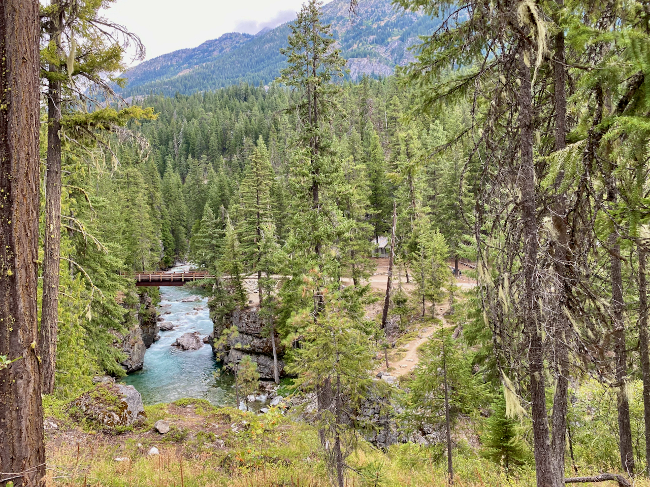
High Bridge
The normal Stehekin shuttle is not running this year, however, the Stehekin Valley Ranch is providing the service which gives you a hour layover at lunchtime to at the Ranch, just right for fueling up on a burger. I then stopped at the Stehekin Pastry Company where I had the best piece of Cherry Pie I think I have ever had.

I then set up camp in the National Park Lakeview Campground and proceeded to down a few brews from the store before it closed at 4:00 pm. The next morning I went back to the Bakery for breakfast and had a nice 2 mile walk back to get ready for my ferry ride back to Chelan.


Goodbye Stehekin
Overall a great trip, but it was also the most difficult trek I have ever completed and now 4 days later I am just starting to feel recovered.

Image Lake via Suiattle River Trail

I finally made it to Image Lake and boy was it worth it. On my Spider Gap Loop trip in 2015 we tried to get to Image Lake but had to turn back. After climbing the last 1400 ft from Miner’s Ridge on this trip I would say we made the right decision to backoff back in 2015. But I needed to get to Image Lake partly for fulfillment and partly to push the body into backpacking shape since this was my last weekend in the North Cascades before retirement the following friday. The trip is 32 miles with 4800 vertical with most of the vertical, 3300 ft, from the river trail. I planned on 3 days but I was not sure how it would play out.
The hike into the Canyon Creek campground was a possible first night destination, however, all campsites were taken thanks to a fairly large PCTA work crew. So I hit the PCT going North and saw that there would be a few campsites before the Image Lake Trail.
Shortly after Canyon Creek Brook and I were attacked by “Max” a combination Shepherd and Wolf. All I heard was “No Max” and around the bend comes Max in full charge. Brook got between my legs and held her ground but Max was only about attack. A serious fight broke out at my feet and I believe Brook realized she was not going to win. I heard a dog cry and then Brook took off running for her life with Max in pursuit. I think Brook chomped on some part of Max’s body which freed her for the get-away. Well Max’s owner chased after Max and I followed calling for Brook. Running with a full pack at my age is not what I should have been doing, but my dog was in trouble. After about a quarter mile Max was contained and I headed up the trail looking for Brook. I found her to be safe and injury free. Wow, I did not really say anything to Max’s owner because he knew how bad this was. He said that it was good that Max was tired. I was thinking it was good Brook is so fast. Overall, this was probably a good learning experience for Brook, to know that anything can happen and it is best to stay close to the Human you want to protect. Brook’s trail etiquette is almost perfect, but people don’t always understand how Aussies want to check them out.
Back to the trail with the temperatures rising to about 80 which was taking a toll on my body.  I would have loved to have been able to climb to Image Lake for the overnight view, but I was beat. Luckily there was a sweet campsite just before the trail to Image Lake. I decided to camp there and go to Image Lake the next day with my new lightweight day pack that I just bought at REI. This was the first time in a while that I have camped in a forest setting with lodgepole type trees with not a lot of distracting sound such as you would get from a rushing stream.
  The evening turned out to be wonderful listening to the wildlife and watching Brook try to stalk all of the local chipmunks. The sun setting between the trees was a whole different kind of beautiful sunset. I even took a selfie.


But I was tired and thanks to splurging by bringing my Therm-a-rest air mattress, I slept like a log. I did not use my fly which did offer some star gazing. Brook started out in the tent but she knew she needed to be outside to properly protect us. I did not try to influence her otherwise even though it was pitch black out.
Sunday morning and it is time to climb to Image Lake.

First Glimpse of Glacier Peak
I knocked off about 2000 ft to Miner’s Ridge as the temperature was again pushing 80.

Second Glimpse of Glacier Peak
The last 1300 ft nearly did me in, but I saved enough energy to properly explore not only Image Lake but the Miner’s Ridge Lookout Tower at 6210 ft. I was the only human up there and it was an amazingly beautiful day. This is why we backpack. The view of Glacier Peak is the highlight, the pan at the top gives you the full perspective.

The Suiattle River Drainage was also breathtaking
There was only snow at the top and Brook was loving it. Here Brook wants to go after a marmot on the other side of the lake.
The rest of the photos will speak for themselves.
Descending back to my campsite nearly did me in, thank goodness it was downhill. But on this second night I was really beat, no appetite either, but a serious thirst that I needed to quench. I put the fly on earlier and decided to leave it which allowed me to just sleep on top of my bag all night. Brook woke me at 5:00 am and I felt good so we hit the trail by 6:30 am. The hike back was uneventful but I continued to realize that my body was benefitting from this extreme exercise. I am writing this post because I am too tired to do anything else. I am going to sleep good tonight. I think I am ready for retirement.

Spider Gap Buck Creek Loop

This Spider Gap Buck Creek Loop trip, Aug 1-6, was the fourth exploration of great loop hikes in the PNW. As expected, this 36-mile loop with 8,000′ vertical was amazing and lived up to our high expectations.
Every year I do a loop like this with friends, and when we have asked other backpackers what they believe to be the best loop, Spider Gap Buck Creek was always referenced. And it is truly an awesome loop complete with incredible vistas, challenging climbs, and unique topography.
We decided to take the counterclockwise route beginning with the Spider Meadow Phelps Creek trail. The meadow was beautiful but it was obvious that we had missed the high flower point by a few weeks.


Taking it easy the first day, we planned for the Spider Gap climb, which is broken into an initial 1000 ft climb on a fairly rugged rock trail and then another 1000 ft climb up the snowfield. The reward at the top was worth the climb.
The view into the Lyman Lakes Valley and Glacier was highlighted by rugged terrain, which turned out to offer up a bit of a scare to us. We made the mistake of assuming the trail to the east would eventually wind down to the valley. Wrong, so I advised that we backtrack and go down the snowfield. Unfortunately, Bob, who hates to backtrack, decided to take the shortcut down the mountain slope. This was not communicated well, and we ended up getting separated from Bob.

The outcome of this turned into a nervous search for Bob who did eventually turn up to relieve our fears after he had a bit of a hair raising descent down the side of the mountain ending up further down the valley. Our concern stemmed from the dangerous loose rock navigation that could easily result in a slide or a fall. But all was well and we settled in between the Lyman Lakes.


The following day took us over Cloudy Pass, which lived up to its name. This was also around the time we began enjoying an overabundance of blueberries and huckleberries. We had a fun log stream crossing below Lyman Lakes. Again, we kept losing Bob because he couldn’t resist stopping to eat the berries.


This is when we first saw the fires that have wreaked havoc with the PCT Trail closure. At this time, the big fires over at Lake Chelan had not blown up yet. As we climbed over the pass, we got to speak with many of the local Whistle Pig population.
This was also when we discovered that the detour to Stehekin was no longer an option for the PCT’ers. We went about halfway to Image Lake and turned around, figuring that the weather was not going to present us with enough reward. After talking to others who went over, I think it was the right decision.


We had hoped to hike over to Image Lake which is a 2.4 miles. We went about a mile and decided we didn’t really need to go all the way. The views of Glacier Peak were excellent from where we were. (I did finally get to Image Lake and yes it is awesome) We camped across from Fortress Mountain. This was the Suiattle Pass Junction area where the PCT closure was spelled out.

We continued on with our loop up to Buck Creek Pass knowing that we would have time for a side hike. We setup camp at the top of the pass while the weather still looked good and we decided to do the Liberty Cap trail.


I highly recommend this route which offers fabulous views of Glacier Peak.

Well the weather started to change once we got up on Liberty Cap which caused us some concern but also offered beauty in the cloud formations.


We got back to camp just in time to avoid the rain.
The next morning it was still miserable on the pass but we could see that there was sun in the valley on our route back to the Trinity Trailhead. The annual backpacking loop trip with friends was again a great success, however, this year I was set to continue on for a few more weeks.

My original plan was to get my resupply and go from Stevens Pass to Canada, however, the fires forced a change to that strategy. So I decided to go from Stevens Pass to Snoqualmie Pass for my next segment.


