My Goto Hikes around the Grand Valley
This post will highlight hikes around the Grand Valley that I use for training and bliss. This will also serve as my resource to use for introducing my grandson to hiking. I will try to link an AllTrails link for each hike to offer some navigation and directions. I would also recommend looking up these hikes on the gjhikes.com site.
I have set up this list from easiest to most difficult.
- Devils Kitchen Trail, 1.5 mile 311′ vertical
- Echo Canyon Trail, 2.4 mile 500′ vertical
- Mica Mine Trail, 2.6 mile 290′ vertical
- Palisade Rim Trail, 3.3 miles 616′ vertical
- No Thoroughfare Canyon Trail, to 1st waterfall ~ 3 miles
- Gunny Loop/Connector, 4 mile 480′ vertical
- Flume Canyon, 5 mile 500′ vertical
- Second Thoughts Loop Trail, 4.8 miles 636′ vertical
- Monument Canyon Loop Trail, 5 miles 750′ vertical
- Pollock Bench Trail, 7 miles 920′ vertical
- Rough Canyon Loop Trail, 4.5 miles 900′ vertical
- Devils Canyon Loop Trail, 7 miles 800′ vertical
Devils Kitchen Trail, 1.5 mile 311′ vertical

The Devils Kitchen Trail located just inside the East portal of the Colorado National Monument is perfect for getting started. I ended up hiking more then the 1.5 mile 311 ft vertical but that was because I was a bit rusty at using my hiking app. But this trail is doable by most anyone who can walk and the beauty offered the inspiration I needed. This hike starts from the Devil’s Kitchen Trailhead which serves the 4 hikes listed on the sign.


Echo Canyon Trail, 2.4 mile 500′ vertical

The Echo Canyon Trail in the Colorado National Monument is a moderately challenging 2.4 mile hike into what is truly an echo canyon. The waterfall is probably dry most of the year but the canyon and water spout is beautiful. This hike starts from the Devil’s Kitchen Trailhead which serves 4 hikes.


The echo canyon is the end of the trail and then you return. There are some minor boulder climbs of about 2 or 3 feet but not too difficult. There is a mining cave in the side wall, but it does not look like it was ever seriously used.


The hike back to the trailhead is just as beautiful. Overall this is a short hike with a lot of scenic value.


Mica Mine Trail, 2.6 mile 290′ vertical
The Mica Mine Trail was a 2.6 mile pleasant surprise for shear beauty. The reviews talk about the incredible rock formations which are totally confirmed. I was snapping photos all the way.

This is an easy hike, however, there are some high stepping in the beginning. You are basically hiking in a small stream canyon with very interesting rock formations, but what impressed me the most were colors & striations of the rock.


Of course the canyon rock formations grab your attention.


The added treat for this hike is the investigation of the old mica and quartz mine.


Palisade Rim Trail, 3.3 miles 616′ vertical
The Palisade Rim Trail gave me a different view of the valley and increased the physical effort to 3+ miles and 600+ vertical. This trail is located on the East end of Palisade up against the canyon wall created by the Colorado River. The distance and vertical were double that of my first hike but just right to create some positive pain in my legs. The fabulous views of the Grand Valley looking west confirmed for me how lucky I was to be living here. The trail is moderately challenging with a loop portion that highlights the view and the back canyon.


I recently returned to the Palisade Rim Trail to checkout the backside Palisade Plunge Trail.


No Thoroughfare Canyon Trail, to 1st waterfall ~ 3 miles
The No Thoroughfare Canyon Trail in the Colorado National Monument was intriguing to me because I wanted to hike the 6 mile version from above, but I needed to hike the popular portion of the trail from the Devils Kitchen Trailhead up to the first 2 waterfalls. I tried to climb above the first waterfall, however, I chickened out so I definitely won’t be doing the longer version of the trail from the upper trailhead. The beginning of the hike offers these amazing fortress views.


You come to a water pool area which is like a small waterfall, the around it is beautiful. You then climb up and over via a fairly nice step climb.


The hike up to the first falls provides more canyon beauty.


The first falls present interesting wall stains from the dry waterfall.


This is where I tried to climb up and over but halfway up I chickened out due to a narrow slanted section that if I slipped up would have been a 50′ fall.


Heading back down to the Trailhead was an easy downhill trek.


Gunny Loop/Connector, 4 mile 480′ vertical

The Gunny Loop combined with the Gunny Loop Connector is one of many trail options in the Lunch Loops Trail area of the Bangs Canyon SRMA. This Gunny Loop reference from AllTrails is pretty close to accurate. This map to the right shows my path. I turned this hike into about a 4 mile 480′ vertical loop with a side link up to a great lookout at 5424′.
This hike is one of many in the area which are designated for foot or bike traffic. I would definitely classify this route a moderate. The trail hiked clockwise offers excellent signage and is well maintained. The first half of the hike offers numerous excellent views of the Grand Valley.


The second half of the trail back to the trailhead provides access to small interesting canyon undulations with views to the South and West.


Flume Canyon, 5 mile 500′ vertical


The Flume Canyon Trail in the McInnis Canyons National Conservation Area does not get high marks for excitement but that is only based on the trail documented on Alltrails. I would rank the area as exceptional using the actual Flume Canyon Trail as a baseline. You definitely want to do the actual Flume Canyon referred to as the Inner Flume. Plus there is reference to the Flume 1 Trail which confuses what should be the best path. I came to a fork in the trail which I assumed was the Flume Canyon Trail because it took me into a small canyon to the east for the actual trail. The yellow line shows my exploration. I knew I was off the main trail but used a path that took me to a small box canyon. I did end up hiking about 5 miles.


Then it was easy to backtrack a bit and find a real trail that took me to the Devils 1 Trail which merged with the east side of the Flume Trail.


Shortly after rejoining the Flume Trail I came across the end of the canyon from above.

As I travelled back toward the trailhead on the Flume Trail I realized that this canyon was the true Flume Canyon and it looked like it needed to be explored. After about a mile I could tell that the canyon was shrinking enough to allow me to find a trail down into it. If I had stayed on the Flume Trail I would have seen the sign designating the Inner Flume which is basically what I was able to access.


Overall this Flume Canyon area was awesome and definitely calls me back to properly identify a new route. BTW, I met a couple my age who had set out to hike the Devils Canyon Loop but got stuck on the Devils D1 Trail taking them over to Flume. As I was leaving I found this out after I offered them a ride back to the Devils Canyon Trailhead.
Second Thoughts Loop Trail, 4.8 miles 636′ vertical

The Second Thoughts Trail is another hike from the Lunch Loop Trail System of the Bangs Canyon Recreation Area, BLM. This moderate 4.8 mile 600+ vertical hike provides almost a constant view of the Grand Valley. I started this hike from the Third Flat Trailhead, but it also appears you could park along the Little Park road and start. I went on this hike after an evening rain and there was some mud to navigate.


I also like the view over to the Colorado National Monument.

Monument Canyon Loop Trail, 5 miles 750′ vertical
The Monument Canyon Loop Trail gives you access to the amazing rock sculptures that you typically take in from the road above through the Colorado National Monument.

The loop is created by combining the trail to Independence Monument and the Unimproved Wedding Canyon Trail. I believe starting the loop counterclockwise with the Wedding Canyon Trail is the most scenic direction. The term “unimproved” is apt, with a few steep sections that slow you down a bit but are not a problem. There are magical views as you approach the Independence Monument section of the loop. This hike takes you below a number of scenic overlooks used by visitors to the National Monument. The photos follow the counterclockwise direction of the loop.


Pollock Bench Trail, 7 miles 920′ vertical
The Pollock Bench Trail is a 7 mile loop with 900+ vertical just east of Devils Canyon is accessed from the Pollock Bench Trailhead. This easy hike offers the different perspective of being above the canyons with great views of the Grand Valley. You are more exposed on this hike so ideal to hike this in the Spring or Autumn. The early part of the hike hits you with most of the climb and the best views of the Grand Valley.


The loop portion of the hike walks you around the top of various canyons that offer unique stone sculptures.


The last portion of the loop offer views back toward Devils Canyon.


Rough Canyon Loop Trail, 4.5 miles 900′ vertical
I enjoyed the Mica Mine trail so much I wanted to go back to take on the Rough Canyon Loop from the same trailhead. This 4.5 mile trek is listed as moderately challenging but I would categorize the canyon portion as difficult. You want to do this hike clockwise which means you start out going down the ATV road which is above the canyon to the north. This first half of the hike is easy with good views of the Grand Mesa. This trail also accommodates ATVs until you begin the return up the Rough Canyon.


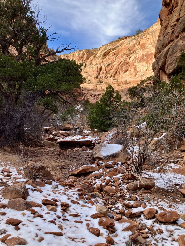
The Rough Canyon return begins with a shift to a less travelled trail that comes upon a sculpted rock trail and scenery. But then you enter into the canyon which on this day in December had a white coat of snow.


The canyon then presents you with one challenging section after another typically requiring you to select the correct route around blocking boulders. If you choose the wrong way just turn around and try another. Lots of 4-5′ boulder climbs which tends to really wear you out.
As you start to approach about a mile from the end you come upon a a canyon obstruction that can’t be climbed over. Then you see stairs leading off to the left which looks like it means traversing along narrow ledges above the unpassable waterfall type area. It does turn out to look worse then it is, but you need to call on your no fear of heights mentality.


The trail goes back to typical boulder climbing, but it does begin to broaden out as you near the finish.
Overall a good hike that does push you physically.
Devils Canyon Loop Trail, 7 miles 800′ vertical
I needed a trail that would push me enough to validate whether I was ready for more serious hikes and backpacking trips in the mountains. The Devil’s Canyon Loop Trail located in the McInnis Canyons National Conservation Area ended up being 8 miles with about 900′ vertical, which when packaged with approaching storms, gave me just the test I needed. The lower portion of the trail before the loop is a nice hike, but the real magic is found on the upper portion.

I had a close encounter with a hummingbird (photo below), which provided me with numerous amazing photos.

The old shed/cabin signifies the furthest point from the trailhead when I realized that the weather was changing more rapidly than I expected.


I had to rush back to the car, which was actually a perfect way to confirm that I was prepared to resume my old backpacking adventures. The Adventure Continues now.
Posted on October 28, 2023, in Colorado, Grand Valley, Hiking, Wilderness and tagged Bangs Canyon, Colorado National Monument, Devils Canyon, Devils Kitchen, echo Canyon, Grand Junction, Grand Valley, Gunny Loop, Lunch Loop, Mcinnis Canyons, Mica Mine, Monument Canyon, No Thoroughfare, Palisade Rim, Pollock Canyon, Rough Canyon, Second Thoughts. Bookmark the permalink. 4 Comments.


Thank you Greg!! So inspiring!!
Sincerely,
<
div>Gretchen
Sent from my iPhone
<
div dir=”ltr”>
<
blockquote type=”cite”>
LikeLike
Oh man, I’m gonna start doing these hikes! Very inspiring!
LikeLiked by 1 person
Pingback: Grand Junction, CO | The Adventure Continues
Pingback: Shingles Adventure | The Adventure Continues