Blog Archives

Great PNW Multi-day Backpacking Loops
I have been putting together an annual multi-day backpacking loop trek for my friends for the last 8 years. The goal was to find a 4 or 5 day trek of moderate difficulty based on a loop to simplify travel logistics.
The first trek was through the Sisters Wilderness in 2011 and during each trek we would ask other backpackers what they thought was another great loop option. This advice truly led us to discover and confirm the finest multi-day backpacking loop treks in the Pacific Northwest. Since I have answered this question for other backpackers through the years I decided to create post to highlight these loop treks. The order presented is based on the order in which I discovered these treks. Please feel free to share your similar favorite loops.
Three Sisters Wilderness
Husband Peak coming down Separation Creek
There is a 50 mile loop that encircles the 3 Sister Peaks, however, I selected an approximate 35 mile route that starts from the Lava Lake Trailhead and cuts through between the Middle and South Sister peaks. This was my first multi-day trek for which I named the post “No Pain No Gain“, reflective of efforts and rewards of backpacking. The route adhered to the 4 to 5 day goal while adding the challenge of being up close to the Sisters. I would recommend the clockwise route with attention paid to water availability on the first day. Camp Lake through to the Chambers Lakes typically presents the challenge of climbing through snow but you need to experience the view from up there. You have to time this trek to allow for the snow crossing while also taking in a maximum floral display without too many bugs. The east section which is the PCT takes you through lush forests into lava fields. Passing through the restricted Obsidian area is not a problem, however, you want to time your climb over Opie Dilldock pass during the cool part of the day. The Mattieu Lakes near the start and finish offer good rest options. You could also consider doing this loop from the Pole Creek Trailhead.
Eagle Cap Wilderness

Glacier Lake – Eagle Cap
The Eagle Cap Wilderness was enticing, however, piecing together a loop was not as obvious. I settled on using the Two Pan Trailhead to enter via the Minam Lake Trail and returning via the East Fork Lostine Trail while taking in all of the options provided by the Lakes Basin area. This loop requires crossing the 8548′ Carper pass to settle around Mirror or Moccasin Lakes. Here you have the option of expanding the loop up and over Glacier pass through Horseshoe Lake to Douglas Lake. Or you could just base from the basin area and do a few day hikes to fill your trek. Either way you must experience Glacier Lake. The lakes here are deep and can provide some good fishing. You come out completing the loop via the East Fork Lostine Trail with a shrinking awesome view of Eagle Cap.
Goat Rocks Wilderness

Valley below Goat Lake
Goat Rocks should end up on everyones list, however, with that popularity come the weekend crowds. The loop option is fairly defined with a starting point at the Berry Patch or Snowgrass Flats Trailheads. It could be treated as a 2 day loop, which is why you include spur hikes north & south on the PCT. Whether you go up Snowgrass or Goat Ridge Trails you will be doing the bulk of the climb and you typically will deal with the worst of the mosquitos and black flies. I like the Snowgrass Trail to the Bypass Trail over to the PCT. Once on the PCT portion of Goat Rocks you have access to Cispus Pass south or Old Snowy north which is worthy of a few nights. Then head over to the Lilly Basin Trail which takes you to the Goat Lake area. The lake is generally iced over, however, the campsite options around there provide an awesome view of the valley and Mt Adams. You may want to hike up to Hawkeye Point and you should be treated to herds of mountain goats above Goat Lake. Your hike out via the Goat Ridge Trail is essentially downhill.
Spider Gap Buck Creek Loop
The Glacier Peak Wilderness provides a classic 36 mile backpacking loop that takes you up a glacier to Spider Gap past the Lyman Lakes then over Cloudy and Suiattle Pass by Fortress Mountain and over to Buck Creek Pass and Liberty Cap. This trek is probably the most true loop and it may be the most challenging especially getting up to Spider Gap. You start at the Phelps Creek Trailhead and head up the Phelps Creek Trail as far as you can in preparation for the climb up the Spider Gap Glacier. Camping near the Lyman Lakes sets you up for the next climb to Cloudy Pass and then around to Suiattle Pass where you get your first glimpse of Glacier Peak. If time and energy allow you should consider including a visit to Image Lake along Miners Ridge. As you work your way around to Buck Creek Pass, Glacier Peak is positioned prominently to the west. Find a campsite with a view of Glacier and take a hike over to Liberty Cap. The final hike out is relatively easy from there.
Timberline Trail Around Mt Hood

Mt Hood
This is a great loop trail around Mt. Hood with views many other mountains. I have decided to do this loop every year because it is so perfect and it provides me with a gauge for my overall health. The TT is approximately 40 miles with a number of potentially challenging stream crossings. The elevation low point is near Ramona Falls at about 3300′ with a high point on the east side at 7350′. There are many choices for a starting point with the most common being at Timberline Lodge. Clockwise is the more common route from the lodge on the PCT which takes you by the Zig Zag Canyon where you should consider detouring up to Paradise Park for an evening. Crossing the Sandy river may be the most challenging before you take in Ramona Falls. The PCT offers you a couple of options, I like the one up toward Yocum Ridge over to Bald Mountain before you head up the Timberline Trail toward McNeil Point. On the north side you cross through some old burns but the beauty is everywhere. Once past the Cloud Cap TH you climb to above tree-line typically crossing many snow fields. Copper Spur is a side trip option and then you work your way down to Gnarl Ridge. All of this area is arid and treeless. Cross Newton creek, pass some waterfalls and head through Mt Hood Meadows Ski Area. The final push is to cross the White River and then climb back up to Timberline Lodge. This final climb can be challenging due to the sandy trail and exposure.
My Annual Timberline Trail Trip Reports: 2017 2018 2019 2020 2021
I hope these backpacking loops help you find that perfect trek.
A recent loop that I have just completed does deserve mention, however, it is more difficult than my top 5. It is the Devils Dome Loop in the North Cascades of Washington.
I will also throw in another option which is partially a loop, The Wild Rouge Loop diverges from the primary Rouge River Trail up to Hanging Rock.
I am moving to Grand Junction, CO, where I have targeted the Four Pass Loop in the Maroon Bells – Snowmass Wilderness to potentially replace my Timberline Trail Loop Annual Trek.

Image Lake via Suiattle River Trail
I finally made it to Image Lake and boy was it worth it. On my Spider Gap Loop trip in 2015 we tried to get to Image Lake but had to turn back. After climbing the last 1400 ft from Miner’s Ridge on this trip I would say we made the right decision to backoff back in 2015. But I needed to get to Image Lake partly for fulfillment and partly to push the body into backpacking shape since this was my last weekend in the North Cascades before retirement the following friday. The trip is 32 miles with 4800 vertical with most of the vertical, 3300 ft, from the river trail. I planned on 3 days but I was not sure how it would play out.
The hike into the Canyon Creek campground was a possible first night destination, however, all campsites were taken thanks to a fairly large PCTA work crew. So I hit the PCT going North and saw that there would be a few campsites before the Image Lake Trail.
Shortly after Canyon Creek Brook and I were attacked by “Max” a combination Shepherd and Wolf. All I heard was “No Max” and around the bend comes Max in full charge. Brook got between my legs and held her ground but Max was only about attack. A serious fight broke out at my feet and I believe Brook realized she was not going to win. I heard a dog cry and then Brook took off running for her life with Max in pursuit. I think Brook chomped on some part of Max’s body which freed her for the get-away. Well Max’s owner chased after Max and I followed calling for Brook. Running with a full pack at my age is not what I should have been doing, but my dog was in trouble. After about a quarter mile Max was contained and I headed up the trail looking for Brook. I found her to be safe and injury free. Wow, I did not really say anything to Max’s owner because he knew how bad this was. He said that it was good that Max was tired. I was thinking it was good Brook is so fast. Overall, this was probably a good learning experience for Brook, to know that anything can happen and it is best to stay close to the Human you want to protect. Brook’s trail etiquette is almost perfect, but people don’t always understand how Aussies want to check them out.
Back to the trail with the temperatures rising to about 80 which was taking a toll on my body. 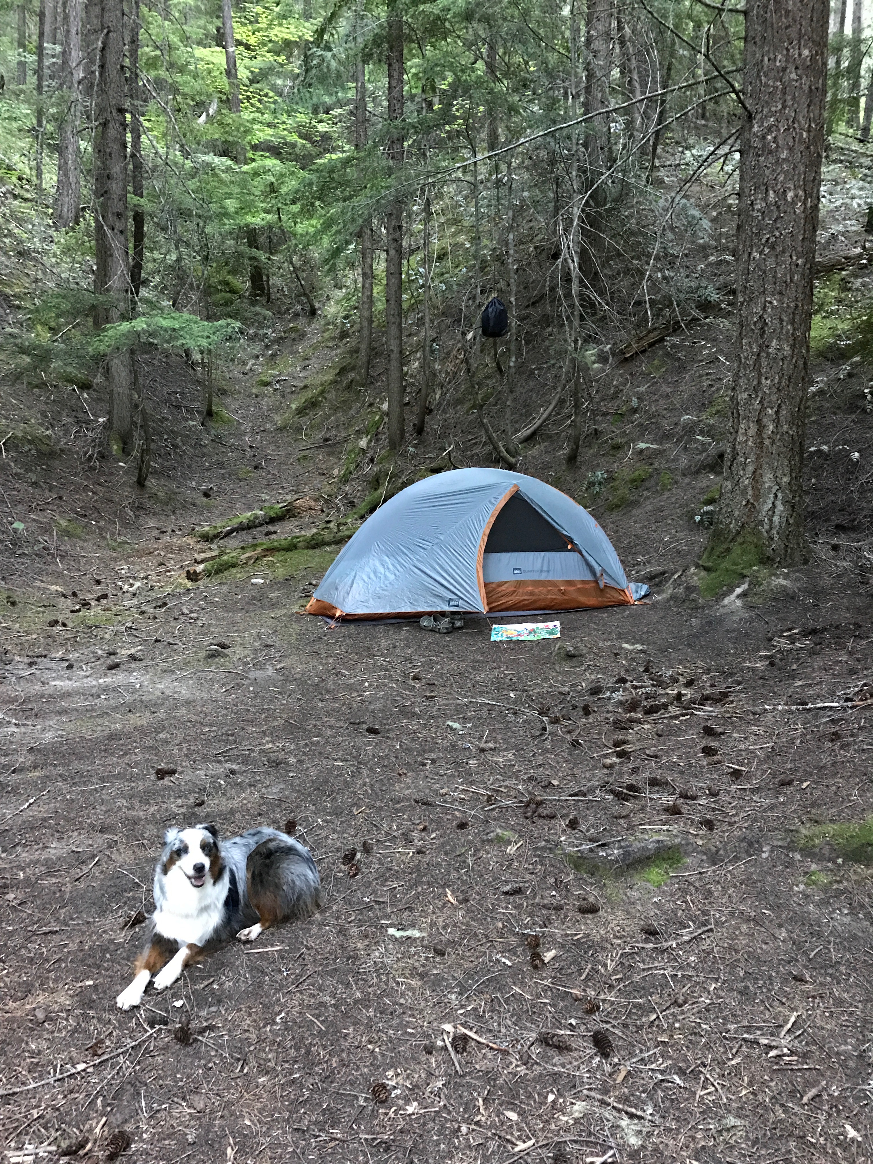 I would have loved to have been able to climb to Image Lake for the overnight view, but I was beat. Luckily there was a sweet campsite just before the trail to Image Lake. I decided to camp there and go to Image Lake the next day with my new lightweight day pack that I just bought at REI. This was the first time in a while that I have camped in a forest setting with lodgepole type trees with not a lot of distracting sound such as you would get from a rushing stream.
  The evening turned out to be wonderful listening to the wildlife and watching Brook try to stalk all of the local chipmunks. The sun setting between the trees was a whole different kind of beautiful sunset. I even took a selfie.


But I was tired and thanks to splurging by bringing my Therm-a-rest air mattress, I slept like a log. I did not use my fly which did offer some star gazing. Brook started out in the tent but she knew she needed to be outside to properly protect us. I did not try to influence her otherwise even though it was pitch black out.
Sunday morning and it is time to climb to Image Lake.

First Glimpse of Glacier Peak
I knocked off about 2000 ft to Miner’s Ridge as the temperature was again pushing 80.

Second Glimpse of Glacier Peak
The last 1300 ft nearly did me in, but I saved enough energy to properly explore not only Image Lake but the Miner’s Ridge Lookout Tower at 6210 ft. I was the only human up there and it was an amazingly beautiful day. This is why we backpack. The view of Glacier Peak is the highlight, the pan at the top gives you the full perspective.
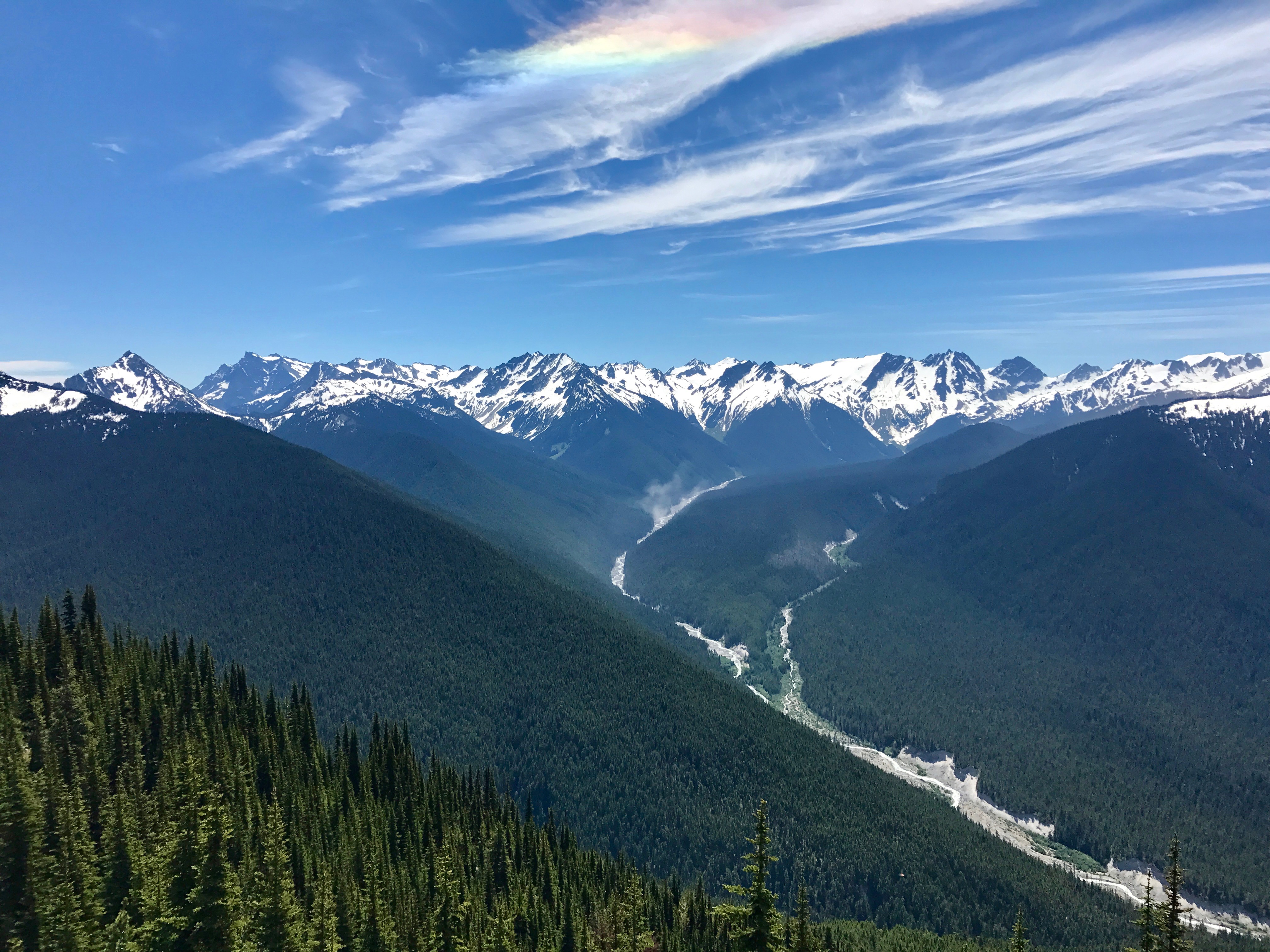
The Suiattle River Drainage was also breathtaking
There was only snow at the top and Brook was loving it. Here Brook wants to go after a marmot on the other side of the lake.
The rest of the photos will speak for themselves.
Descending back to my campsite nearly did me in, thank goodness it was downhill. But on this second night I was really beat, no appetite either, but a serious thirst that I needed to quench. I put the fly on earlier and decided to leave it which allowed me to just sleep on top of my bag all night. Brook woke me at 5:00 am and I felt good so we hit the trail by 6:30 am. The hike back was uneventful but I continued to realize that my body was benefitting from this extreme exercise. I am writing this post because I am too tired to do anything else. I am going to sleep good tonight. I think I am ready for retirement.


